
Torrey, UT
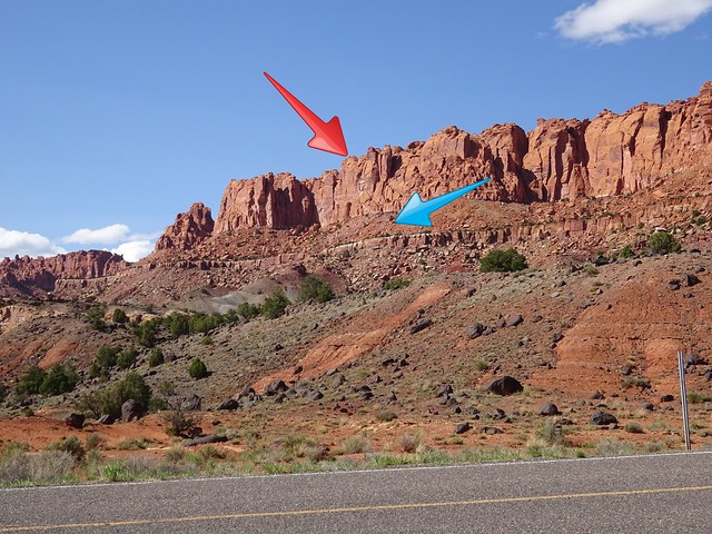
Our friend Annette, who lives near Torrey, told us about a hike just east of town that goes up to the top of Meeks Mesa. We did a bit of research and found that the trail is just west of Capitol Reef NP on land that is part of Fishlake National Forest. The hike has two distinct parts. The first part of the hike goes up to a narrow flat area known as Cooks Mesa. The trail goes along Cooks Mesa for a bit over a mile before entering a steep canyon that leads up to Meeks Mesa. The photo below was taken from Rte. 24 with the blue arrow pointed at Cooks Mesa and the red arrow at Meeks Mesa.
The trail begins in a popular drycamping area on the north side of Rte. 24 just west of the national park entrance sign. The locals refer to this area as Campsite 73 (it is locasted at mile marker 73) where people boondock while waiting for a spot in the national park. The trailhead is not marked, but as you enter the drycamping area and drive to your left you can see it going up a hillside.

The trailhead in the dry camping area
The first part of the trail leading to Cooks Mesa ascends steeply through the multicolor Chinle formation. One particularly grueling section involves climbing the spine of a gray-green hillside straight up with no switchbacks.

The last part of the three hundred foot climb to the first mesa is through an area of large, colorful boulders.


Once on Cooks Mesa the trail flattens out and lets you catch your breath while enjoying great views to the southwest and some unique rock formations.

Climbing on to Cooks Mesa


The nimble hiker riding Dino the Dinosaur
At 1.1 miles the trail on Cooks Mesa goes by an area with a number of petrified wood stumps.


Just under two miles from the trailhead the trail moves toward a steep ravine on the right. Our goal is the end of the trail on the top of Meeks Mesa shown by the red arrow in the photo below. This is where things get interesting!

The trail winds up along the wall of the mesa, then heads straight up the ravine.


The trail goes around this rock formation
This trail is described by many as an old cattle trail. As we hiked we commented that it was hard to imagine cows going up or down the trail. But about half way up we came across bones of a rather large animal.

Further up the climb we found the remains of a wire fence that once protected the trail on a switchback. OK, maybe they did drive cattle up and down this trail!

But the steep trail above us still left us with our doubts!


Finally, after climbing over three hundred feet in less than a half mile, we came to the top of the mesa. Total gain in elevation from the trailhead was over a thousand feet.

The top of the mesa doesn’t have any defined trails, so we just set out to explore following some faint trails used by animals. There is a large cairn at the top of the trail but we added another one nearby to help us find the trail for the hike back down.

Lunch with a view
With no defined trails we knew it would be a bit tricky to find the trail back down off the mesa. There are at least four ravines along the side of the mesa, but only one has the trail back down. But we felt that if we just hiked along the rim of the mesa we would be able to spot the trailhead. Wrong! We missed the trailhead and ended up hiking way further up the edge of the mesa than necessary. After two hours and 4.2 miles of searching the edge of the mesa, we finally spotted the cairns that marked the trail and, much to our relief, began the descent.

Heading back down the ravine

Last section to the trailhead
The hike up to Meeks Mesa is only four and a half miles roundtrip. But with our exploration on the mesa and a long hike searching for the trailhead to go back down, we ended up with a hike of over eight miles. We returned to the Jeep tired but pleased we were able to complete this difficult hike!

Where are your trecking poles?
Dick, if you look closely at the last photo, I have them:) We didn’t use them going up. It was easier to use the rocks to help us. Poles would have been in the way. But coming down I used one pole and then got out both once we were down out of the steep rocks off Meeks Mesa.
Where are your tracking poles?
I love your lunch with a view pictures. Dino the Dinosaur had a cute gal riding it! Neat trail! Looks dry… rain must have stopped!
Thanks, Nancy! We actually got one day rain free:) It was so nice. But don’t worry, we had snow, sleet, and rain the next day. Next week looks great!
Crossing my fingers for you to have that nice weather you are hoping for!!
Why don’t you use a GPS?
We think about gettign one, but we have never needed one before. John actually realized we could have used the map on the hiking app we use and mark our entry point…oh, well, next time:)
I only ask because we are considering getting one.
We’ve actually looked at them, but decided that we haven’t really need one. We usually have researched our trial and carry written direction many times. John knew where we needed to be, we just needed to walk closer to the edge to come across it. This was my first panic in all the hikes we’ve done:) We did have our SPOT button so I knew we could get rescued:)
Yikes, I bet there were a few anxious moments on that hike! We have a couple of GPS and I usually carry one with me just in case. We also use them for geocaching but as of late we have been concentrating on the hikes themselves rather than the “treasures” buried along the way. You can easily double or triple your time of you look for geocaches along the way.
Really liked the stumps, we have yet to run across any of those.
With all the hiking we do, this is the first time we have had trouble. I was a little panicy but John knew exactly where we needed to be. It was jsut a matter of hitting the opening. Once we stayed closer to the edge, we came right upon it. Thanks goodness we had a nice day and hours of daylight left so “exploring” the mesa was fun.
What a tremendous hike! I feel pleased with myself if I do 10,000 steps. And then I don’t get the views you find.
The scenery along the way and the great views do make some of our climbs worth all the effort:)
Yeehaa! Not content with bull riding, nimble hiker takes on a dinosaur ;-)) Looks like this might be a good trail on which to drop some breadcrumbs 😉
Haha! Thanks, Erin! I’m really spreading my wings:) Funny you should mention breadcrumbs, because I actually had that thought as we continued to wander!
Wow, that looks like a whole body workout! It’s kind of freaky to lose your way back down isn’t it?! Looks like a fun day on the trail!
It was a great full body workout, for sure! The climbs were fun and too long which made them more enjoyable. With all of our hiking this is the first time we have had this trouble. But John knew exactly where we needed to be so he was fine. It doesn’t take much to worry me. But I was rather freaked out
I love all the pics of you guys on the trail – and of course the dinosaur ride! The extra 4 miles of searching doesn’t sound like much fun, and I can just imagine your feeling of relief at finding the trailhead! Glad you had a good weather day and got back safely.
Wasn’t Dino just the cutest! I couldn’t get over much the rock looked like a dinosaur. You described MY feelings exactly as we wandered. While the scenery and the rocks were beautiful, I was having trouble fully enjoying it:) Yes, I was thrilled when I looked up and realized we’d found our way down.
That looks like quite the hike! I have been in that situation a couple of times where I couldn’t find the trail back…not fun. Glad you made it down safely. Hope you are having a lovely Mothers Day Pam. 🙂
Thanks so much, LuAnn:)
I was a little tense for me as we wandered, but John kept saying we weren’t lost. He knew which direction we needed to go. We just weren’t staying close enought to the edge to find the path down. But we got in lots of extra miles!!
Lots of extra miles is not a bad thing. 🙂
That is one of the places we boondocked last October. Great location, and we did the hike up the mesa but don’t think we went as far as you did. It was steep, but worth it for the views! We still haven’t gotten around to getting a Spot device but keep talking about it.
I was wondering if any of you did this hike. The hike up to Cook Mesa is a nice one. But you have to go over a mile and half north across Cook Mesa and around the bend at the end. Then you go back into the canyon opening climb straight up there. That last part was crazy. I would never believe they got cattle up there, except for all the bones.
We really wanted to get the SPOT button for Anza Borrego more than anything. We have done Jeep roads way out alone and then hiked and we don’t see anyone. So that concerned us. It does give us some comfort.
Where is the photo of the nimble hiker being bucked off by the dino? hehe
Gorgeous trail. Petrified wood just amazes me. It looks so prehistoric.
When you say straight up, you are kidding. That looks like a monster of a climb. We know exactly how you feel not being about to find the trail. Been there; done that. A few anxious moments to say the least. Another beautiful day on the trail!
Luckily I was able to stay on Dino:) Yes, I am also amazed with petrified wood…a very strange process. There were a few very anxious moments for me. John was fine and said we had a nice day and seven hours of sunlight left to find the path down. But it only took two hours:)
Looking at the photos of you climbing up through the boulders I was thinking, “How do they know where the trail is?” And then to find out that you were wandering around on top of the mesa for a couple of hours searching for the trail — oh my. I’ve been lost on trails and it’s no fun, especially when darkness sets in. So glad you had plenty of daylight left to find your way down. I’ll bet you were happy when you finished that hike! (The photo of you riding the dinosaur is adorable — but you forgot to bring your saddle!)
Laurel, there actually was a trail that was pretty easy to follow all the way up to the top of the second mesa. There were plenty of cairns to gelp us through the rocks. When I look up at areas like that, I always wonder how in the world we’ll get through. Thankfully, some brave people always find the way for us:) This was our first “lost” experience. We weren’t actually lost, as John says, we just couldn’t find that darn trailhead down. But John knew where we needed to be espeically after we walked the entire one side:) I thought that rock was so adorable. It was John’s idea to ride it. Glad he thought of it!
The Dino rock is cute, but the trail is too steep for me…eeek! Can’t beat those views though!
Nina
Like Laurel I was wondering if there were cairns to guide you or if the trail was obvious enough. Looks like a real workout in the good sense. But why didn’t you just have Dino take you on up? Fabulous views. I so distrust GPS’s after the ridiculous way the ones we’ve had for the car can’t get us anywhere in the most direct manner that I’ve never even considered having a handheld one and am so out of it I don’t even know what a spot device is. Is this what happens when I don’t watch TV, go shopping or surf the internet? I get left behind. LOL