
Bluff, UT
For one of our last outings here in the four corners area of southeastern Utah we decided to take David and Karen to the Moon House Ruins, a very neat set of ruins up on Cedar Mesa. We drove about fifty miles to the Kane Gulch Ranger Station to purchase hiking permits. These ruins have become popular for hikers and there is concern that they could be harmed by too many visitors. To prevent this only 20 permits are issued each day. Since we didn’t even see another car on the drive to the ranger station and there were only a couple of cars in the parking lot, we were not too concerned . But we were disappointed to find that there were no permits available for the day, nor were any available for the next two days.
OK, time for a change of plans. We asked the volunteer at the ranger station about suggestions for another hike in the area and were told that the trailhead to the Junction Ruins was just across the road. This hike would be a bit longer than the one we had planned (just under five miles one way compared to a mile and a half) but we had plenty of food and water and a great deal of enthusiasm, so off we went.
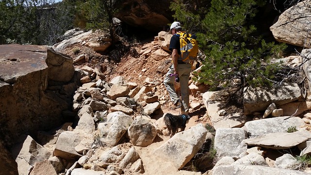
The volunteer in the ranger station must be quite a hiker as she described this hike as being pretty flat and easy. We found it to be a bit more challenging than her description. The trail was rough with many climbs around pour-overs. Since we were following a wash down stream, we knew we would face a more difficult challenge on the return hike when we would be going up stream!

As we hiked further down the wash the views all around us were quite impressive.

We named this Big Tooth Rock


The temperature was very comfortable, but our hike leader constantly looked for shade along the trail.

After hiking a bit over four and a half miles we rounded a bend and could see the ruins in the cliffs in front of us. This is a two story settlement. It looks like the upper area was the living quarters and the lower (behind the bushes) was used for ceremonies and cooking. There is no access to the upper level so we could only explore the the lower level.

We passed a primitive campground with a few tents in it and made our way up and into the lower ruins.

In the center of the ruins was the remains of one of two kivas at the site. A kiva is a chamber, built wholly or partly underground, used by male Pueblo Indians for religious rites.

Remains of a kiva
There were also two large boulders with marks made from the grinding of grain.


Some of the rocks were clearly used to sharpen tools.


Two young archaeologists discuss artifacts in the ruins

Two hikers enjoy lunch among the ruins


Pottery shards
The area in front of the ruins is roped off as it is a midden, an area used as a dump for residents of the ruins. Pottery shards, corn cobs, and burned pieces of wood are readily visible in the midden.

As we prepared to head back up the trail we suddenly lost the leader of the pack. Apparently he was more than a bit reluctant to leave the cool shade of the ruins.

We quickly convinced our leader to get back on the trail and the group began the slow climb back up the wash.

Passing “Big Tooth” on the way back
After a long climb back up the wash and out of the canyon we were happy to see the trailhead gate in front of us.

While everyone in the group was a bit tired as we drove back to Bluff, the leader of the group just couldn’t keep his eyes open for the drive! After all he did hike all nine miles this time!

The disappointment of not being able to obtain permits to visit the Moon Ruins turned into a blessing in disguise. We’ve completed a number of great hikes during our two visits to this area and the hike to Junction Ruins ranks close to the top of our favorites.

Just looking at the first photo, I can see no flat or easy hike for today.
The colors in the rock in that area is just so beautiful. I love the swirl and layers of browns.
What an awesome ruins. It is pretty rare that you can actually pick up a piece of history and investigate it. How cool.
Did your leader do this for free or room and board? He better get his act together or he will be out of business fast.
It certainly wasn’t a flat hike, Marsha. There were some flat areas throughout but the trails going around the pour over were quite a climb up along the ridge. It wasn’t too difficult.
Cody hikes for snacks:) He knows I carry several little snack bags with his treats counted out.
Moon House Ruins has been on our list, too. But now we’ll also add Junction Ruins! It looks like a fabulous hike. Have you guys been to Monarch Cave Ruins or the Wolfman Petroglyph panels? They’re both in the area and I think you would love them. They’re both short hikes, but unique and spectacular. (http://ravenandchickadee.com/?s=monarch+ruins)
Laurel, we did the hikes you mentioned two years ago when we were here. There are many hikes out Butler Wash along with these two. Our friends went out there today.
Moon House ruins are so neat. We have a blog on the site from two years ago. What we enjoyed about these ruins was that they are so solid and complete. You can go inside where there is a hall with rooms off of it. There are also several other ruins each way along the ledge, as well.
The Junction Ruin was special because of all the artifacts left. Turkey Pens Ruin is another .7 of a mile out. But I was concerned about adding another 1.4 miles to an already very long hike and tough climb back out. Our friends are new hikers and we had to make sure Cody could make it. But you and Eric can add that to your trip:)
I should have known that you’ve been on every possible hike in the area! I’m taking notes on all of your hikes this time and now I’ll go back and check your archives from 2013. You guys are great. 🙂
Love that tooth rock. It really does resemble a tooth…. how unique. Stunning country and the photo of your leader is too darn cute.
It was a super cool rock. We were there for quite a while taking photos from all sides. The golden colors were beautiful. Yes, Cody is a special little guy:)
Either the ranger has a strange definition of flat or s/he hasn’t actually hiked this trail and is confusing it with another. Love that picture of you and cutie patootie! This looks like a super hike. Does seem serendipity to me that you got to see it. I am amazed at how little destruction there is and how things are left alone by the usually me centered public. I just love Native American ruins and would be thrilled to go there myself. Thanks for putting it on my list.
Sherry, I hope you and David get the opportunity to hike this area. There are endless ruins everywhere. We just scratched the surface.
What a wonderful Plan B! Your trail leader is such an inspiration to those of us with short legs 🙂 Pam and Cody look like a puzzle piece fitting in the rocks, and the dead branch like an extended hand with finger and thumb touching. So encouraging to see artifacts left undamaged for others to enjoy.
It sure did turn out to be the perfect plan, Jodee. Sometimes change works for the best. David and Karen wouldn’t have seen the artifacts at the ruins we were originally going to see. So this turned out to be a bless in disguise:) I had this hike planned for John and me one day when they went somewhere else. Glad we saw it together. It was nice to see so many artifacts left alone.
What a great experience. Jealous!
I wish the folks in our group were hikers but I bet there will be lots to see without hiking too far! Thanks for providing us all this great info!
Make sure you check out our blogs from 2013, Janna. We did eight straight days of hiking and Jeep roads.
Another fun hike! Fantastic that your pooch can do 9 miles.
Another one to PIN! That tooth was very cool, I’m glad the second shot had a human in it for size perspective! Cody is adorable!
Lisa, you and Hans will really enjoy this hike but do keep going another .7 to Turkey Pen Ruins and then another .3 to a natural arch for about an eleven mile round trip. I was afraid to push this with new hikers and Cody.
Who wouldn’t follow a cute leader like Cody? What a real champ!
Had to go back a couple of posts…you have found some great places to explore! Love the ruins…
Have a great time in Moab…happy trails!
We are back in Moab!! Not our same site but a really nice site. I was just going back through your posts to check out your mild Jeep trips. Exciting times:)
That little leader of yours knew he was going to have to start the uphill slog back so seemed to be dragging out the start as long as he could. I can’t wait to spend some quality time in Utah. My head is stuffed with all there is to do thanks to you two.
You are right, LuAnn! Cody had no desire to leave the shade and walk all the way back up out of the canyon. He’s one smart dog:)
Wow you found my lost molar! And it morphed too. It will take us days going thru your archived for you had done so many hikes and all of it have impressive views. Only determined hikers like you would look for plan b if a does not happen which as it always happens turned out to be as good if not better than the original.
Haha! Good one, MonaLisa!! The tooth rock was very cool!!
There is always a Plan B and even a C in the back of my mind:) We wouldn’t want to rest after all!
Pingback: A Glimpse of Past Inhabitants – Bluff, UT | The Lowe's RV adventures