
Moab, UT
The area around Moab is a mecca for Jeep enthusiasts. You can find a trail nearby that will fit any level of vehicle and driver. Some of them even have names that reflect their difficulty, like Metal Masher Road or Hell’s Revenge. Our Jeep is “trail rated” but we have not added any of the enhancements enabling us to drive those real challenging tracks, and we have neither the driving ability nor the desire to do them anyway. We bought this vehicle so we can get back to remote areas and it does a great job at it.
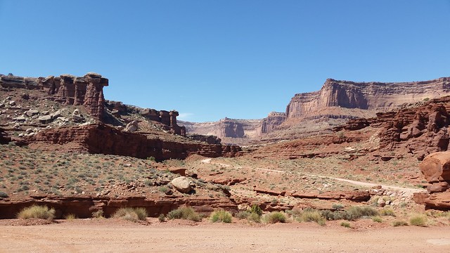
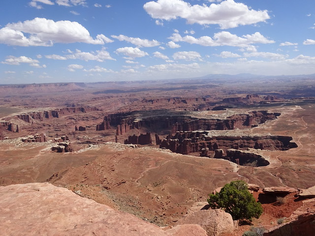
One of the rides we really enjoy in this area is the Shafer Trail Road (also called the Shafer Canyon Road), an eighteen mile dirt road that takes you across a mesa directly under Dead Horse Point State Park and above the Colorado River. The road enters Canyonlands National Park not far from the White Rim Road and ascends the canyon rim in a series of long, stunning switchbacks. These switchbacks provide scenic views of the Colorado River basin and the La Sal Mountains.
To reach the road from Moab, go north on U.S. 191 to its junction with Utah Highway 279. Turn left on Highway 279 and go all the way to its end at the potash plant. The route turns to dirt road and starts climbing up terraces along the Colorado River.
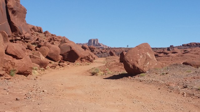
Entering the dirt section of Potash Road
The road soon passes the evaporation ponds of the potash plant.
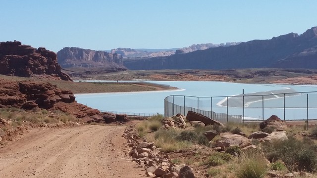

The scene behind us as we viewed the evaporation ponds
We stopped at a terrace with great views of the Colorado River.
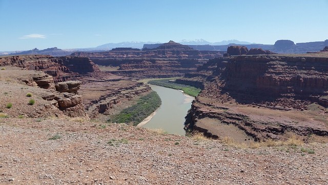
In the distance we could see Potash Road as it meandered into the canyon toward the intersection with Shafer Trail Road.
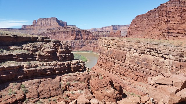
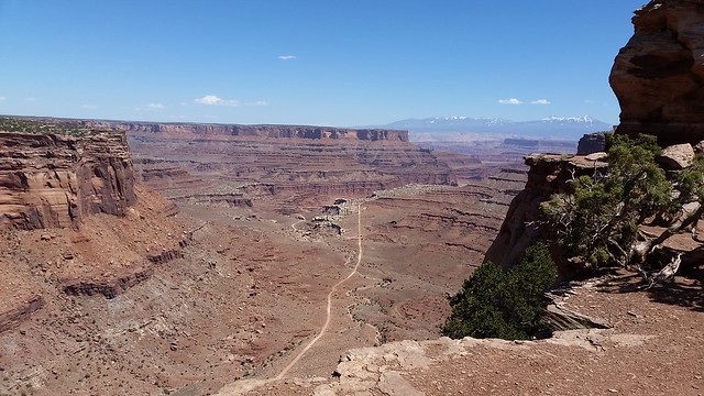
At the “T” where Potash Road meets Shafer Road and White Rim Road we turned left on to White Rim Road for a four mile drive to an arch. The road was a bit narrow and right on the edge of a cliff.
Soon we came to the Musselman Arch.
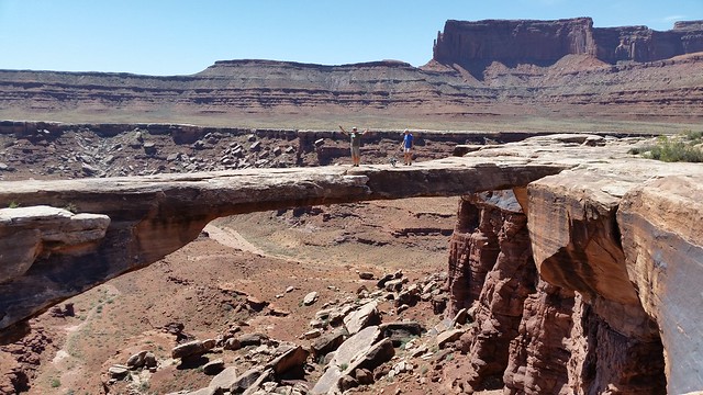
John, Cody, and David walk across the Musselman Arch
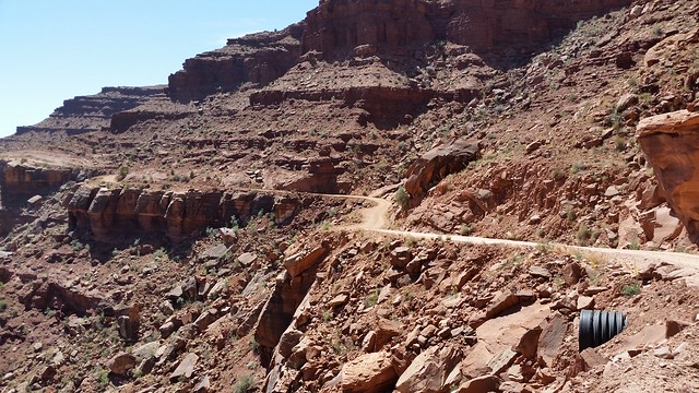
We then drove the four miles back to the intersection and continued up Shafer Trail for five miles. This is where things get interesting as the road goes up the canyon wall in a series of switchbacks. At the top we spotted a young hiker sitting along the canyon rim overlooking the road below her.
Once up on the mesa the Shafer Road intersect with paved road in Canyonlands National Park. We turned left onto the paved road and stopped at an overlook just past the Island in the Sky Visitor Center. The overlook allows you to look back down the canyon at the Shafer Trail Road as it comes up the canyon wall.
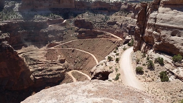
The switchbacks of Shafer Trail Road
The view of the Shafer Trail Road as it approaches the switchbacks
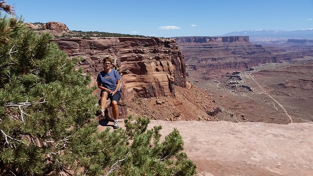
Continuing into Canyonlands NP, we stopped to check out the view from Mesa Arch.
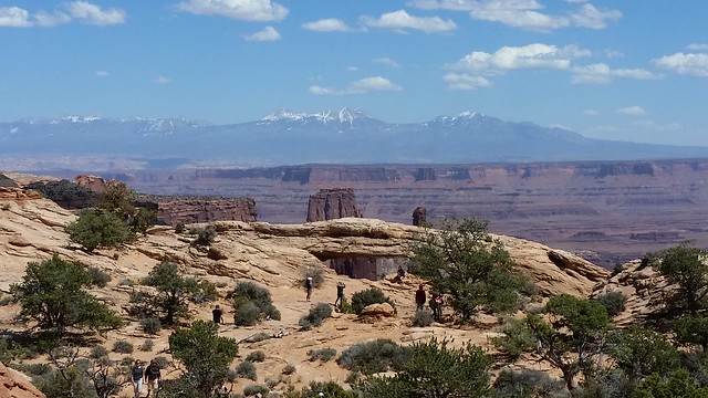
Mesa Arch with the La Sal Mountains in the distance

Looking through the Mesa Arch
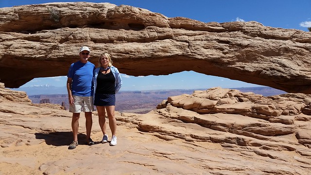
David and Karen at the Mesa Arch
We continued to Grand View Point where the road terminates. A paved path goes along the rim with great views to the east.
The Colorado River is down there somewhere
We had planned to come back down Long Canyon Road but the hour was late and the winds were steadily increasing as predicted. So we took the paved road back to US 191 and returned to Moab, leaving the Long Canyon Road for another day.

Your pictures look as though the Shafer Canyon Road you travelled could be driven by a vehicle without 4 wheel drive. Would you say this could be done?
You don’t need 4 wheel drive for the road but there were a few areas where high clearance was needed.
That’s the answer I was looking for! Lovely scenery like this is always an enticement.
Just the sight of those red rocks, the switchbacks, and vistas makes my heart pound faster and faster! Wish we were there!
It won’t be long before you arrive, Gay:) The Shafer Trail was smoother than we remembered it. Last time we didn’t stop at the Musselman Arch so I was glad we saw it. Can’t wait for the weather to clear so we can do Long Canyon.
Soooooo beautiful, but far too scary for me. I’m glad I can enjoy it from afar thro’ your blog pics!
Nina
Yes, Nina, we do think of you on these roads:) You can just ride along on our blog!
Beautiful! Love those red rock vistas!
Very cool tour — that one photo looking down on the switchbacks looks a bit scary! Guess that’s one that we won’t be driving with the Tundra, so thanks for taking us along!
Laurel, you can easily drive it with your truck. You don’t need 4 wheel drive:) You would really enjoy the road and the amazing views!
Oh good! Our Tundra has 4-wheel drive, I just wasn’t sure if we would be too long for the winding road. Seems like we’ll be fine, though.
You should be fine, Laurel:) The switchbacks were tight but wide so you will make.
Looks like a great trip! Those outside turns always look so much narrower from the distance. Love the views of the river cutting its path through the valley. Now standing out on that arch? Maybe not 🙂
Jodee, a few of the areas were that narrow! If we had met someone, one of us would be backing up. The river was so beautiful from so far above:) I did not stand on this arch. It was just a little too narrow and I didn’t like how it was attached to the side.
Yeah I don’t know that I want to go stand on that arch either but boy this makes me want to be there now! Oh well, our turn will come!
Yes, your turn will happen, Denise! We waited eight years once we decided this was the retirement lifestyle we wanted:)
Beautiful photos! The jeep trails look a little scary to me as well, but it looks like you guys truly enjoyed your trek! Years ago we jeeped in Ouray and I will always remember those rides.
Thanks, Sheila! We do enjoy our Jeep but we don’t do anything that scary…usually:) We need to stop in Ouray and spend some time this summer.
I, too, am glad we had the opportunity to ride along with you. As Nina says, it looks a little too scary for me though. I would have just died if Dave would have had to back up allow someone to pass. I noticed that you let your handsome and trusting husband go out on the arch, you know, the one you didn’t think was safe…..Sue
Your new Jeep will love these roads, Sue! I was not a fan of John going out on that arch at all, but off he went!!
How is it when you take the same trail we do you see so many more things? We never saw either of those arches on our drive!
Next you should try Chicken Corner. We did not get to it when we were there but were told that it is very easy and only has one corner that makes it a little scary but is no worse than anything on Shafer.
The Musselman Arch is four miles off the Shafer Trail. We didn’t drive out to see it our first trip either. The Mesa Arch was actually on our way out to the point in Canyonlands Island in the Sky. So if you just drove the Shafer Trail, you wouldn’t have seen it.
We have read about Chicken Corner. Maybe we’ll give it a try:) Thanks for the suggestion.
Gorgeous photos of really beautiful country. So many beautiful vista and backdrops on that one hike… I can see why it’s a favorite. Thanks for sharing.
Yes, Holly, everywhere you turn the scenery is beautiful. This is an amazing part of the country.
Just caught up on your last few postings…just love that part of Utah. My daughter, who lives in SLC and works in Park City, said the wind the other day was wild, and the snow the next day made her late to work. We sure did not like driving in the wind ourselves, but it seems to have calmed down now (in Needles California). –Dave
Luckily, we didn’t the snow here in Moab but we did drive up into the La Sal Mountains yesterday and it was snowing quite hard. We saw all the snow SLC got. Not pretty this time of year but so necessary. It is good have the winds calmed down. Glad you made it to CA. You are moving right along. Travel safely to Sacramento:)
Loved this ride along with you! We’re with Nina and Sue…just a bit too adventurous for us and our Ford truck…it’s just too wide for some roads to share and the thought of backing up….
Thanks for these fabulous photos. We’re sharing on our FaceBook page since we’re off the road a bit with family matters!
Kelly you would be fine:) We did see a few trucks on our journey. Now duallies would make me nervous…way too wide. Glad you are enjoying the photos on Facebook. Thanks:)
Fabulous photos. I love that part of the US. The La Sal Mountains look so awesome in contrast to the canyon.
Musselman Arch photo is terrific. Very unusual that you can actually stand on the arch rather than beneath it.
That trail looks a bit scary to me. The road looks very narrow. Glad y’all have nerves of steal.
The Musselman Arch is very similar to Devil’s Bridge in that you are above the arch rather than below it. The road actually leads you to the top. This arch went all the way across the span so you could walk from one side to the other and around. I didn’t go out on this one. For some reason it made me uncomfortable.
We thought of you as we were driving along this road. Looking ahead could be a little unnerving when you can see how narrow the road is in places. But it really was fine and we saw very few vehicles which made it nice for stopping whenever for photos.
The last time we visited Moab we were thinking of buying a Jeep so we rented one. After driving almost 100 miles in one day, including the Shafer Trail, which was not all that bad compared to a few of the other roads we took, we decided jeeping was not our thing and bought a Subaru Forester. It gets us almost everywhere we want to go. I would rather hike on those rough, rocky roads than be a passenger in a Jeep!
We love our Jeep and its ride is very comfortable but we have the basic Wrangler Sport Unlimited. It fits our limits. We have found that most of what we like to do we only need high clearance. The 4 wheel drive has been used more for deep sand and steep hills. I’m sure the Jeep you rented was tricked out some which would have changed the ride. Since our Jeep is our everyday vehicle, we want it comfortable so no tricking happening here. Glad you are happy with your Subaru Forester:)
Hey, big kudos to you adventurers for doing that drive. We’ve looked down on it from above and couldn’t imagine driving it! You are a brave bunch and inspire us all.
It actually looks worse than it is, Lenore. The road was actually in very good shape.
What a fabulous drive. It was a drive we, well mainly I, DB wasn’t so keen, would’ve loved to have done. But even though our Ford truck has high clearance and 4WD it doesn’t have a great turning circle. Just the thought of having to possibly reverse to get around some of the switchbacks made us (DB) decide against it.
The switchbacks weren’t that bad. You wouldn’t have any trouble. We did a couple trucks out there. The trail was in great shape this year.
Oh Boy! We were there and your gorgeous pictures bring back so many memories. We didn’t drive the trail since we don’t have a jeep or a high clearance vehicle but we looked down on that road and wished we did. Thanks so much for driving it for us. Your pictures are really fantastic. I don’t climb up on arches because I don’t want to take any chance at all of damaging them and you just never know what’s going to push them over the edge to former arch status.
Thanks for coming along with us, Sherry! Glad you enjoyed the photos:)
Beautiful country. Love those photos of Mesa Arch with the La Sal Mountains in the background. 🙂
It was a quick stop at the Mesa Arch with only a couple photos because the wind picked up and we had heads and lips full of sand. Not good for the camera. But it was a nice view. The La Sal’s should be gorgeous today after all the snow they received yesterday.
I would love to walk to that arch! But I don’t think our little car can make this drive. So Im glad we are riding with you on this one and you took us to some beautiful sceneries all around.
I also like your new header, great reflections.
It might be time to think about a Jeep!! They tow beautifully:) Thanks for noticing the header:) It was last time we had calm winds.
WOW! WOW! WOW! Fabulous trail! I wish we had our older Jeep Cherokee when we were up there. (Our older jeep is what takes us on the back trails here in AZ) but we had our new Jeep Cherokee and it is more of a trip car and everyday car. Looks like the rain stopped for you!! HAVE SO MUCH FUN!
Nancy, you could have done this road with your new Jeep Cherokee. It wasn’t that bad, just a little narrow in spots. Yes, the rain during the day had stopped but we did have a short storm last evening. Hopefully that is it for awhile. The Shafer Trail was closed for two days because the switchbacks get slick when wet. We are having a blast! Thanks:)
We rented a jeep and did this in reverse order you did. Quite hairy coming down those switchbacks, though I can’t imagine going up is any easier!
Pam, we’ve never done this road in the reverse. I am sure it was just as interesting:) We did Long Canyon today in both directions and that was really different.
Such amazing scenery and pictures! We have recently made a move further into Western Canada which positions us closer to Utah and some of the other “red rock” states. Definitely want to search out this one! No jeep though. Do you think a Honda Civic would navigate this road?