
Boulder City, NV
Friends, Steve and Joan (FOSJ), are spending the winter in the nearby Lake Mead Recreation Area serving as volunteers. The main part of their assignment is to drive a park vehicle down the many, many back roads in this huge area and check on road conditions (the infrequent rains often wash out parts of the roads), placement of guide signs, and any misuse of the park. We have shared dinner with them a few times during our stay here and recently they told us about two interesting roads nearby in Arizona that lead down to the Colorado River. So twice this week we spent some time 4-wheeling in the desert.
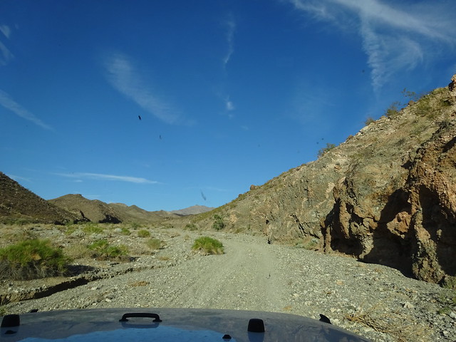
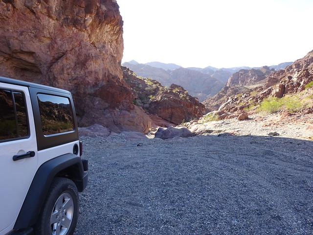
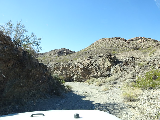
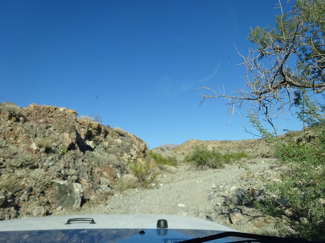
The two roads (designated 61 and 62 on park maps) are about two miles apart and are accessed off of US-93, about ten miles south of Hoover Dam. After turning off the nicely paved four lane Rte. 93 you immediately enter a narrow dirt road that often isn’t even really a road, but a path down a dry wash. We’ve driven a number of back roads here that require a high clearance vehicle but these are the first where you definitely need four wheel drive, as much of the time you are in very loose soft sand. If you take a two wheel drive vehicle down here bring plenty to eat and drink while you wait for assistance!
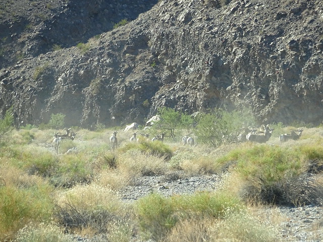
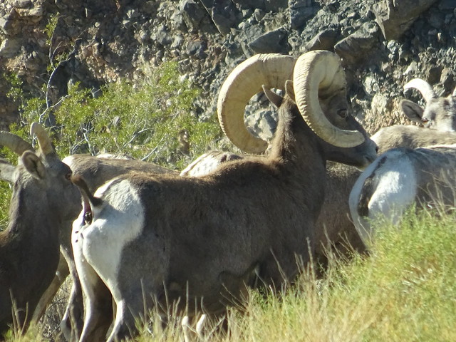
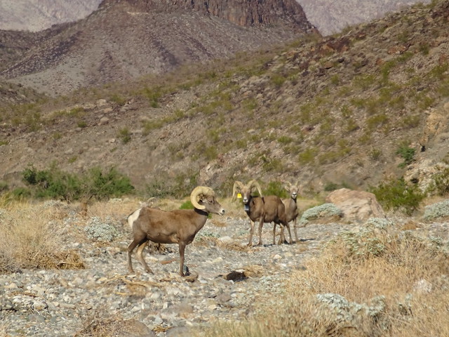
The first day we took the road designated as 61. This was the easier of the two roads and did not require too much time in four wheel drive. About two miles into the drive a cloud of dust suddenly appeared about fifty yards in front of us. A large heard of Big Horn Sheep had suddenly entered the wash, running down the steep wall of the wash.
The dusty entrance
From the look on their faces they seemed as startled to see us as we were to see them. (OK, maybe you can’t read the emotions on the face of a sheep, but they did stare at us!)
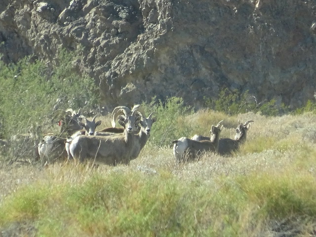
We sat still for quite a few minutes while the sheep enjoyed a snack. When they finally moved off the road, we continued on our way.

Sorry, bugs on the windshield
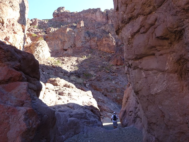
After four miles, we came to the end of the road (literally). From there it is a half mile hike down to the Colorado River.
The hike has some interesting views as you make your way down the wash.
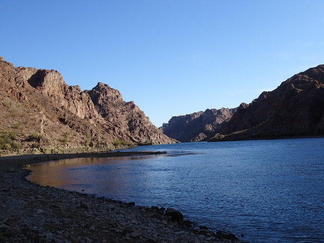
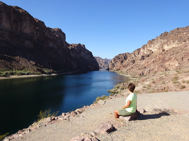
At the end of the wash you are rewarded with some beautiful views of the Colorado River. The water south of the Hoover Dam is technically part of Lake Mohave, a reservoir created by the Davis Dam near Laughlin, NV, but it looks more river than lake to us. Before the dams tamed the river, this area was filled with fast flowing rapids, so we guess the “lake” designation is appropriate.
After a snack at the river we headed back up the wash to the Jeep.
We were a bit surprised to find our friends still enjoying a snack along the road. Again, we sat for a while until they decided to move to greener pastures and let us through.
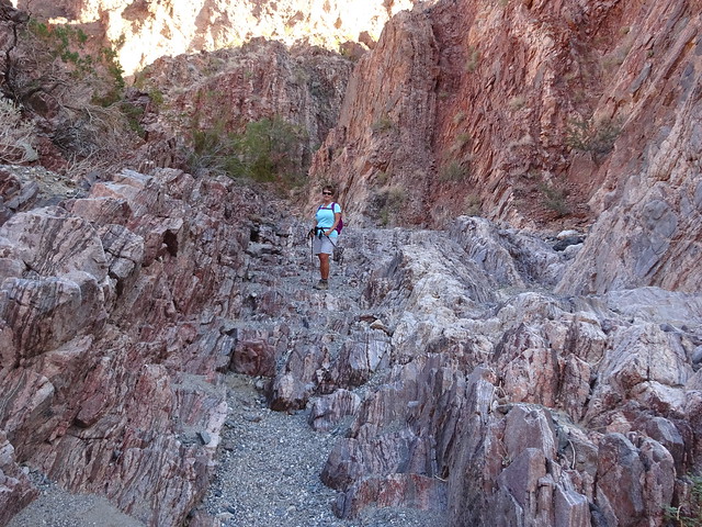
The next day we drove back into Arizona to check out the second of the two roads. As we said, this one required the use of four wheel drive for over half the time due to the deep sand.
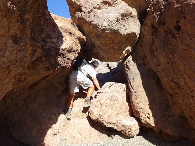
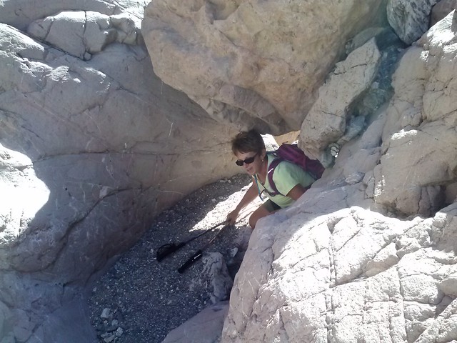
We drive the four miles to the end of the road where we found a sign (thanks Steve and Joan) telling us it was .8 to an old ranger station. While it is a pretty easy hike, the first part requires a bit of scrambling in two adjacent spots.
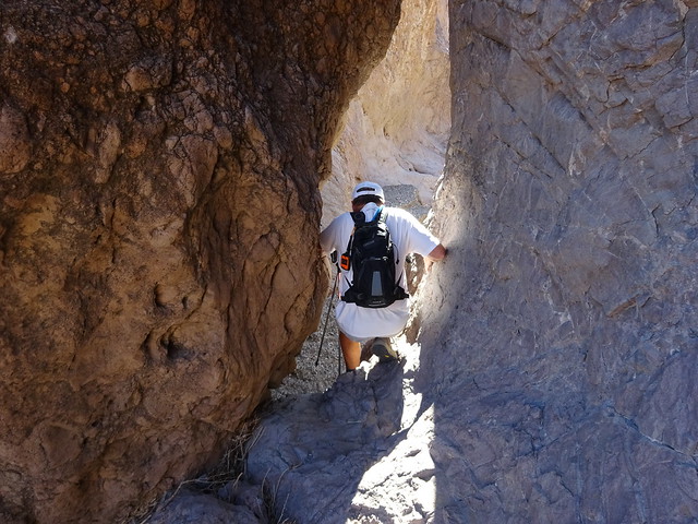
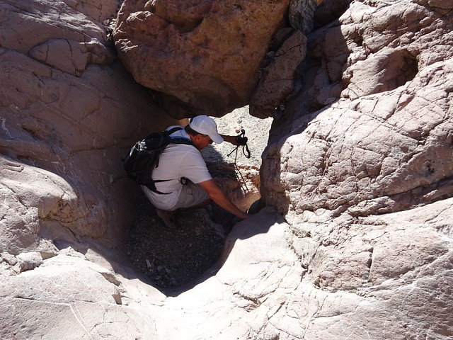

Once through those two spots, it is an easy walk to the river (lake?). At the river there is a trail that runs up the north side of the wash leading to the remains of two buildings on the bluff overlooking the water.

Hiking up to the building remains
A beautiful view looking north
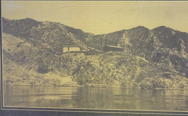
The two foundations are all that remains of a Gauging Station built there around the time of the construction of the Hoover Dam. The station was built to provide data on the depth and flow of water in the Colorado River. Pictures on a display board at the site show the two buildings from that time period.
River view of the two buildings
In the picture below, the building on the upper left was the residence for the gauger, while the one on the lower right was a garage.

The buildings have been removed, leaving just the foundations as evidence of their existence.
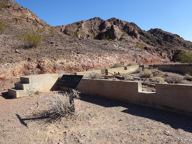
Residence building foundation
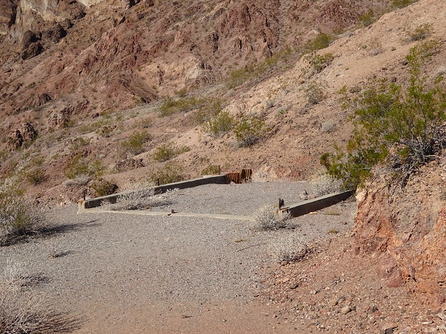
Garage foundation
Looking up river you can see the remains of the actual facilities used by the gauger to measure the river. In the picture below, red arrows show structures built into the canyon walls on each side of the water. On the right is the remains of a catwalk along the canyon. Each day the gauger would hike from the residence to a cable attached to the catwalk. He would use a little tram on the cable to get from the trail to the catwalk, then use another cable stretched across the river to ferry himself to the structure on the opposing wall of the canyon
The gauging station itself is a small, square metal room hung on the vertical cliff about forty to fifty feet above the river surface. Beneath it a corrugated pipe about four feet in diameter extends down into the river. The gauger would use this pipe to measure water depth.

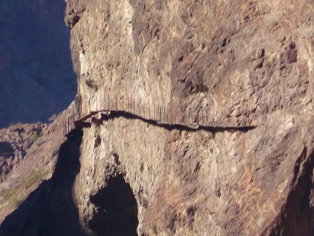
The catwalk
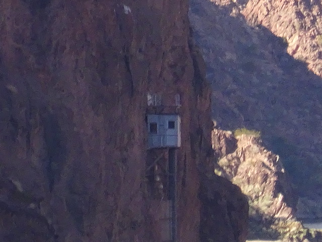
The gauging station
We are a bit confused as to when this station was constructed and put into use. The information sign at the site states that it was constructed and used in the late 1920’s and early 1930s, before Hoover Dam was constructed. A National Parks Service document we found that describes the facility states that the station was constructed in 1935 and used to measure water after construction of the dam.
After watching kayaks on the water while enjoying a snack at the remains, we headed back up the wash to the Jeep.
Many thanks to Steve and Joan for telling us about these two adventures. The Jeep really enjoyed the work-out and we loved the short hikes down to the water. And the Gauging Station was very interesting and satisfied one member of the group’s need to explore history.
We are now about to end our stay in Boulder City. When we arrived we intended to stay for two weeks, but found so much to do that we extended our stay twice. Even with the extensions we have barely scratched the surface in exploring the area. But it is time to move on and Death Valley has finally cooled down a bit and is calling our names.
More on that later . . .

This looks like a “hike” I would enjoy! I’ve marked it in my little blue book, although I have begun to figure out pinterest so I’m slowly coming into the present age! John, your close up picture of that ram show he’s doing more than enjoying a snack, wink wink
Sue
Sue, when I took that photo I was zooming on the curled horns!! We had no idea anything was happening at the other end til you and Lisa commented. John said you aren’t suppose to be looking at that end:) But it was good timing wasn’t it!!
How cool to see a herd of big horns! The poop shot is a crack up!
Lisa, as I mentioned to Sue, that wasn’t the purpose of my photo. Haha! I was looking at the horns. We didn’t even notice that was going on until you and Sue mentioned it. John said you aren’t suppose to look at that end:) But it was good timing!
I’m afraid our Subaru isn’t going on those roads! Jim would probably give it a try but I wouldn’t let him.
Road 62 most definitely not. That road was narrow, rutted, rocky, and tons of very deep gravel and sand. We did have to use our low 4 wheel drive once on this road which we rarely have to use. You could probably do 61 if you have four wheel drive. This road wasn’t bad at all but did have a few places with deep sand where John put it in regular four wheel drive. But otherwise we didn’t use it all. We even passed a nut on a motorcycle as we left. He was all over the road. Must have been a long four miles for him.
Sure Pam, sure….we believe you. You just wanted to see if we were alert.
Haha! Glad you were paying attention, Sue:)
Some great shots of Rams in full curl!!! I like the way you hike, too 🙂
Box Canyon Mark
Thanks, Mark:)
What a beautiful but rugged looking hike. Again, great photos – especially of the Big Horn Sheep. It’s really amazing to see how close you actually got to them.
The catwalk? I think I too would take that photo with a zoom lens!!
Thanks, Rick! All the sheep we have seen seem quite tame which makes for some great photos.
The catwalk was only four boards wide someone told us…not for me!
Love the looks of those hikes. We really need to get a 4WD or start caravanning with someone who has one. Very interesting about the gauging station. Sounds like a neat job using a catwalk and a tram every day. But the flock of Big Horns now that’s nothing less than fantastic.
Thanks, Sherry! We really lucked out this time with seeing such a large herd of sheep.
A high clearance vehicle will get you lots of places. This is the first time in a while that we needed four wheel drive but we have needed the higher clearance often.
I wonder how many people had to scroll back up to see what they missed. I did! I can’t believe all the big horns you saw! We saw a group today but they were cued up for the tourist by the highway headed to the dam. Enjoy Death Valley!
Joan, I had to go to the blog to see what I missed!! I was aiming for the other end:)
Those Big Horn Sheep are beautiful. I can’t believe how they stood there for you. There can’t be that many vehicles that go back that way for them to be that tame.
I like the combination of driving and hiking. What a lovely view you were rewarded with on both hikes.
Don’t even give it one little thought…the answer is NO….I will not go out on the catwalk. Not for $1,000! I’ll send Paul.
Safe travels to Death Valley. Fill up before you leave for that area. Gas is atrocious. If you haven’t visited Scotty’s Castle, it is pretty cool.
Thanks, Marsha, we are all fueled. Not sure the Jeep will make for five days but better that than the MH!
All of the Big Horn Sheep we have seen have been pretty tame. We are always surprised how they just stand there and look at you. This herd was fantastic. A perfect way to end our stay:)
Both very nice drive/hikes. Really love that area. If you do visit Scotty’s Castle, the basement tour is a must. It is so interesting.
Thanks, Rebecca, for the suggestion. We aren’t sure we will get to the castle with all the hiking and backcountry roads we want to do. But you never know:)
In a months time I don’t think there are still untrodden trails at the rate you were exploring. Great shots of those Big Horn sheep which I think are actually your lookout as you were hiking.
We did do many hikes, MonaLiza, but there were still several I wanted to do that we didn’t get to. It is amazing how many hikes there are surrounding the lake.
I never thought about the sheep watching out for us. You may be right since they seem to appear on many of our adventures.
You had the kind of days I would love to have more often…beautiful roads, cool wildlife, interesting hikes and even a little history. We had those on our 6-1/2 week trip, but it will be a while before we go on another long journey.
Good job on your photos.
Thanks, Susan! We are having a wonderful time as we travel the country.
Some beautiful country there! I am still laughing at the “poop shot.” I missed it too. Can’t wait for posts from “DEVA!” I really enjoyed my time there last May, even though it was so hot. I hope to return one day and explore further, but meanwhile I will enjoy it through the lens of the intrepid hikers!
Ha, I noticed the poop shot but was too polite to say anything. Glad to know that your other astute readers weren’t too shy. How cool to see so many sheep. We’re hoping to see some this winter while we’re in Anza Borrego. It’s always such a thrill.
Someone could probably learn a lot about all of us by seeing who was looking at which end in that photo. I started at the heads as I love these Big Horn Sheep and have not seen such a large herd. But, then, I did a double take at the other end. It would be wonderful to have a jeep or similar vehicle and have access to these smaller wash jeep trails. I am not sure how our Big Red (F 250 diesel, off road, 4 wheel drive pickup truck) would do in deep sand and gravel…
A wonderful hiking adventure, with lots of good photos, wildlife, great scenery, and fabulous weather. Enjoy your next adventure hiking!
That’s a couple perfect days, combining off-roading and hiking is the best! And water at the end is such a bonus!! The sheep are amazing – rarely see a big herd on the move like that 🙂 Great pics of the scrambling through the rocks!
I too noticed that “interesting” shot of the bighorn. I can’t believe you two haven’t checked off all the hikes available in the area yet. Looking forward to reading your Death Valley posts. 🙂
Pingback: Hiking and Meeting Friends in Boulder | Oh, the Places They Go!