
Baker, NV
Sunday morning we pulled out of Utah Lake State Park in Provo, UT and drove south, then west as we headed for the little town of Baker, NV (pop. 64). Baker is at the entrance to Great Basin National Park, where we knew there was some mountain hiking in our future.
After about an hour we joined US-50 heading west toward Nevada. Parts of the road are quite scenic as it winds through and over rocky passes.
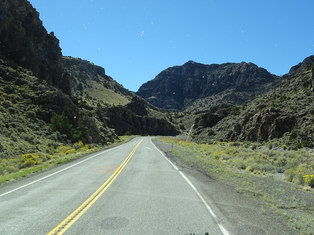
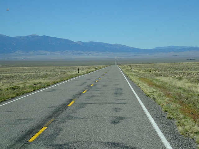
But for the most part US-50 lived up to its nickname, “The Loneliest Highway in the US.” If you follow the pavement in the picture below you may be able to see in the distance that the pavement lightens a bit. That’s the state line between Utah and Nevada. The town of Baker is at the base of the mountains.
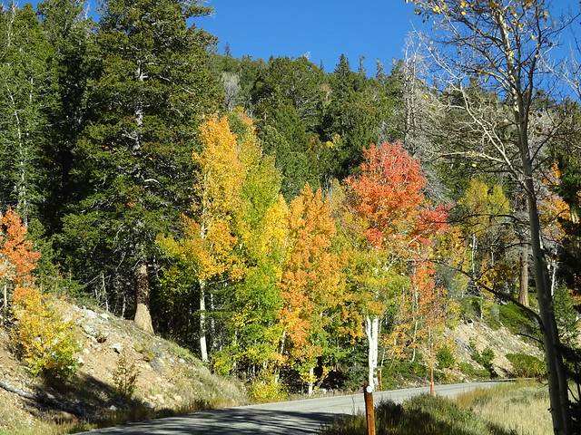
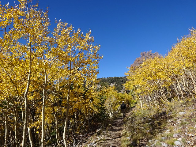
Bright and kind of early the next day we were in the Jeep heading into the park for some hiking. Great Basin is one of the least visited national park, so we were not surprised when we didn’t see another car on the 16 mile ride up into the mountains to the trailhead. The Aspens are in full color so the drive was one beautiful scene after another.
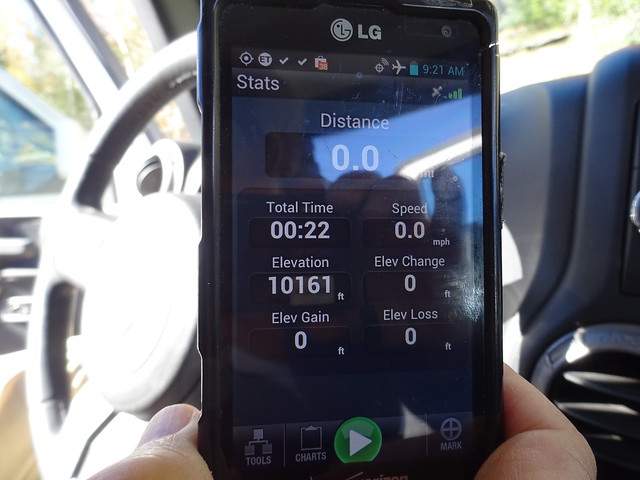
The town of Baker is at an altitude of 5,300 feet and the road in the park rapidly gains some significant elevation.
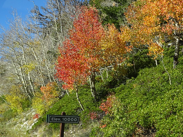
Our old hometown in Pennsylvania was at an elevation of about 950 feet. When our son was a flight instructor, he did much of his flying at under 5,000 feet over Georgia. When we parked the Jeep at the trailhead we were already at 10,161 feet!
The trail began with a gradual increase in elevation through colorful stands of Aspens.
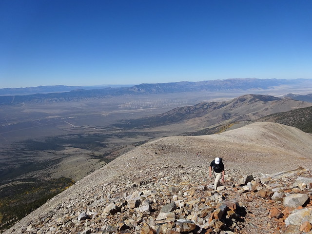
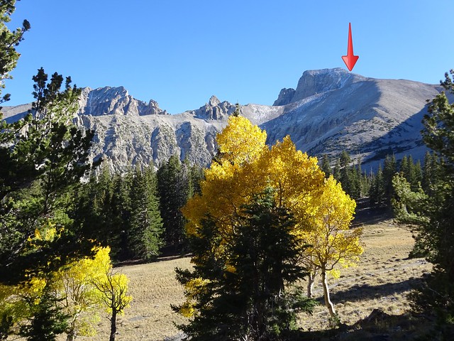
We were hiking the Wheeler Summit trail and we could see our target in the distance as we hiked. This hike is the most challenging that we have tackled, so we were a bit concerned. After all, Wheeler Peak (13,065ft.) is the highest independent mountain in Nevada. Wikipedia describes the hike this way:
“The Wheeler Summit trail is quite strenuous, and the altitude presents significant hazards for unprepared or inexperienced hikers.”
Were we prepared? Are we experience? We decided to do the hike, with the idea that we would turn around if and when it was necessary.
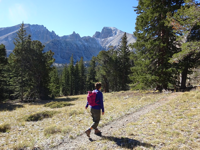
Our goal, Wheeler Peak is on the left
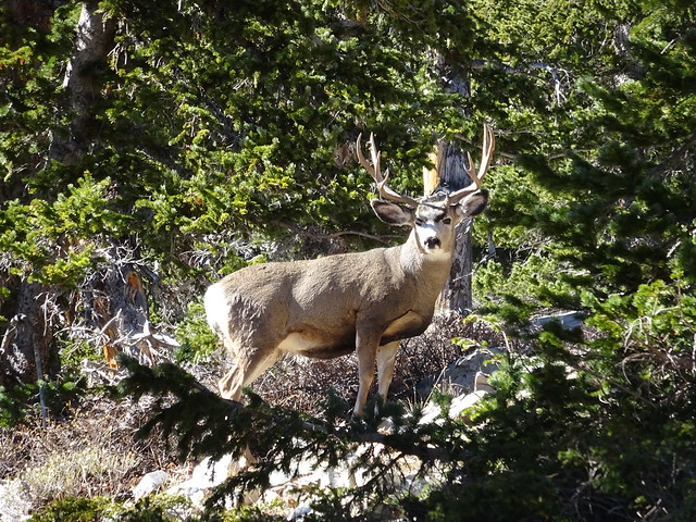
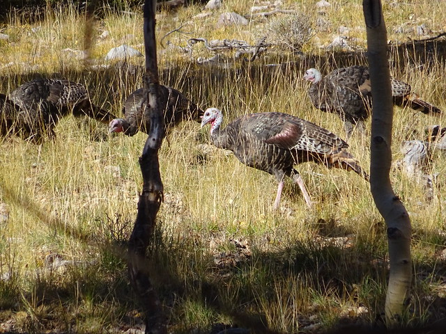
As we hiked up through the Aspens, we found the trail blocked by a couple of hungry locals.
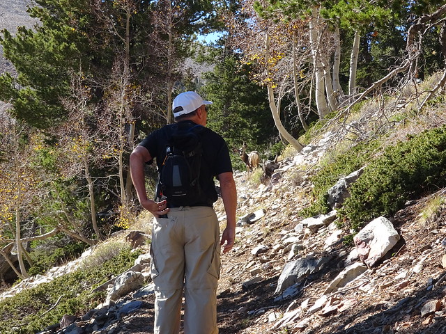
Can you see who is blocking the trail in front of us?
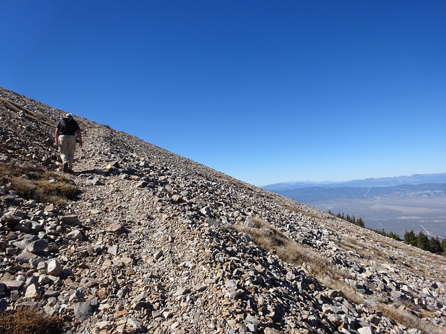
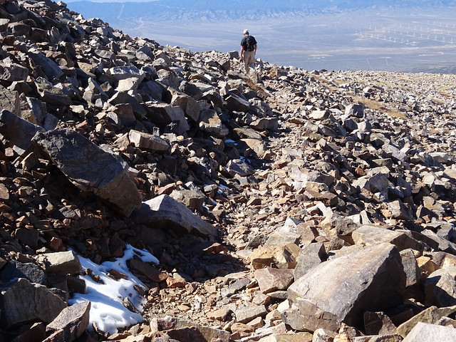
After moving slowly up in elevation for about two miles, the challenge began! All vegetation disappeared and the trail went vertical over loose, broken rock called scree. This loose rock is very difficult to walk over, making the trail even more of a challenge.
The views as we gained more elevation were impressive.
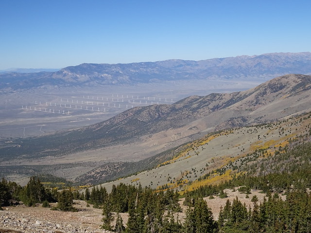
A wind farm in the distance
Did you ever fly across the west and see all the crop circles below you? We were so high up that we had a view similar to an airplane.
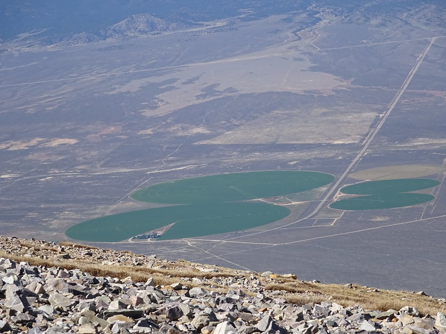
Just like the view from an airplane
As we crossed 12,000 feet the trail just continued upward over the loose gravel.
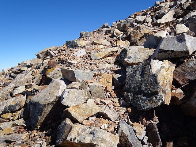
A close-up of the trail
At 12,500 feet we came to a small level area where we ate lunch and evaluated our situation.
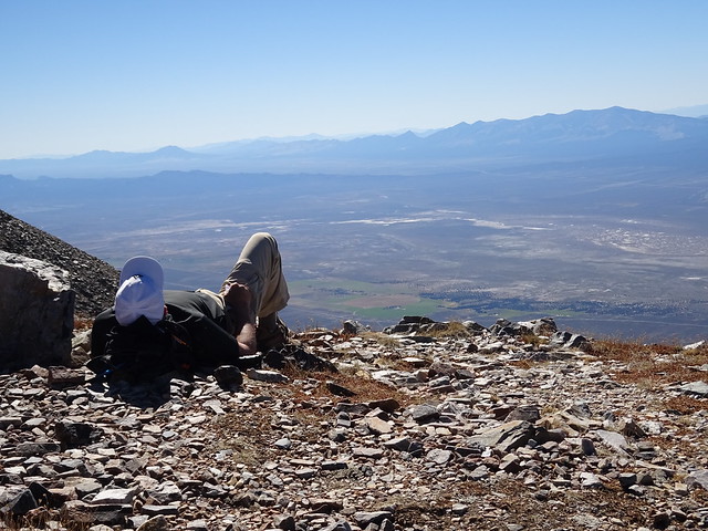
The view below . . .
. . . and the “trail” above
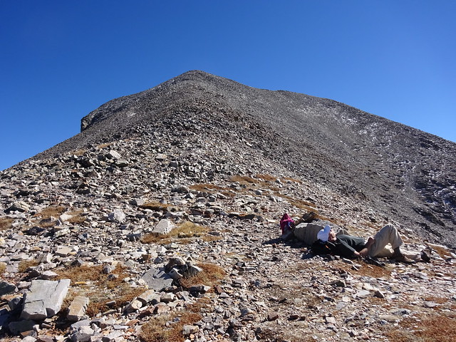
We talked with a couple of hikers on their way down and found that just above us the trail was covered with snow and ice. Hiking up a very steep, rocky trail on ice with shaky legs from the rocky trail and lungs screaming sounded a bit irresponsible, so we decided to head back down. We haven’t hiked above 8,000 feet yet, so this altitude was extremely challenging. As we made our way back down the two miles of steep, rocky trail, we knew we had made the correct decision.
Heading back down
As we hiked back into the Aspen forest we could look back and see the point on the peak where we turned around.
Along the trail we observed a flock of wild turkeys moving through a meadow.
After a long, strenuous hike, the nimble hiker was in no shape to prepare a meal so we decided to visit the only restaurant open in Baker, the LectroLux Cafe. This past September Yahoo Travel included it in its list of “Restaurants in the Middle of Nowhere — That Are Worth the Trip” . So how bad can it be? Well, let us tell you. The dining area only has three booths, a large table for six, and a short bar with four stools. As we entered, the server said we could share a booth or table with one of the couples already seated as they encourage their patrons to get to know each other. We were a bit tired and not in a mood to get to know another couple so we opted to sit at the little bar. The young man working as a server (husband of the young lady doing the cooking) was enthusiastic but not very competent. He started by telling us they were out of many things on the menu but he would check to see what they did have. We opted for one of the two selections available, a quesadilla, since that was what the other ten patrons were having. After a wait of about a half hour we decided we couldn’t it on the stools anymore, so we asked for our order to go. No problem, he said, as our order was just about to come out of the oven. A half hour later we still had not received our order (a man who came in after us had his!) so we decided it was time to leave. Appparently our waiter and his wife, the cook, were not too concerned, as they continued talking as we walked by them on our way out the door! So much for the Yahoo Travel rating.
Oh well, it was back to the motorhome for some snacks, football, and an early bedtime, as the nimble hiker has another exiting hike planned for tomorrow.
More on that later . . .

That looked like a serious hike and I really thought you went all the way. How does it feel to be 12500? The last time I was that high I was on a small airplane and felt really weird.
About leaving a restaurant, we did have same experience but it was at the Beer Museum in Potosi. We sat there ignored for ten minutes, not given water or asked for drinks and just like you the people after us were served first. With tummys growling we left. You did the right thing for leaving.
Have you noticed that the tree on the left of your header looked like a face with a long nose. Nice header!
Actually, MonaLiza, I felt worse coming down. I felt similar to how I get when landing in a plane. My head felt like it was going to burst. It is from my sinus’s. But as long as we were standing still we felt nothing but as soon as we started to hike (going up) you felt heavy and slow. Then we would adjust some. We used our first two easy miles as our adjustment to 10,000 ft. Do you think that was enough time…haha!!
Just looked at the tree in our header and I do see the face:)
We love Great Basin NP and have been in both spring and fall. I thought we were good hikers, but you two are amazing! We’ve hiked just about every trail in the park except going all the way to Wheeler Peak because I don’t like hiking on scree. Too bad about your experience at the LectroLux cafe — we had a glass of wine there and that was fun, but ordering dinner and not getting it would most definitely not be fun.
Laurel, we are off to hike the Bristlecone/Glacier trail and maybe add the Alpine Lake if we feel all right. Anything after yesterday will be much easier:)
Agree you did the right thing in turning around…if for no other reason than the scenery was prettier at lower elevation with all those beautiful trees showing off for autumn! I would like to explore this park next year, but I know nothing about it, so I am looking forward to the next posts!
Suzanne, we are going to check out one of the campgrounds in the park today. We’ll include a photo. There are several campgrounds in the park (no hook ups) with water and pit toilets. It truly is in the middle of nowhere!! Come with everything you need.
A challenging hike … altitude and loose terrain. You were smart to turn around. The highest we’ve hiked is at around 14000 feet at Lake Titicaca … slow and easy we went, with the added advantage of a paved trail. Had the terrain been scree, we would not have made it. Too bad about that restaurant … not the way you wanted to end your day of adventure. I guess the owners are not interested in repeat business.
Oh, Erin, a paved path would have been heaven. We would have been happy for just fewer rocks. The rocks wore us out.
Lovely header!
Our friends, who are in Provo, sent photos of the trees. They are just gorgeous.
Of course you two are experienced and well prepared. Well, wait just one minute…I don’t see your special coffee in your hands? Maybe you aren’t as prepared as I thought you would be.
WOW….that is high for sure dear friends. I am sure the breathing might have been quite a challenge. The view is amazing though. Glad you didn’t decide to take on the snow and ice. That would have made me very nervous to read!
Knowing Paul, we would have walked out after the first half hour. He has no patience for incompetent people. You lucked out anyways…I am sure the food was awful.
Thanks, Marsha:)
Breathing was a problem. We got much better as we went but did A LOT of resting to let our hearts calm. We, also, drank constantly and ate little bits as we went. But that air is real thin up there, even my legs knew it!!
I see most of the snow melted allowing the trail to reopen, glad you got to hike on the trail… now after reading your account I am glad it was closed for us 😉
There is only a little snow in the woods and the highest peaks. Pretty much winter is over here with the great temps we have had. And, yes, it was good the road was closed for you:)
That looks like one brutal trail…steep, loose, exposed…WOW! There is nothing easy about hiking over 10,000 feet (unless you live in Ouray ;-). Fantastic views and wildlife sightings! Good job, you two!
Thanks, Lisa:) We need to get into shape for those big over 10,000 foot hikes if we hope to visit Ouray and its star hikers:) It was a wonderful hike and we worked very hard to get to 12,500 feet for the first time this trip.
I would love to visit this NP and hike some of the trails, but have to say that this one would not entice me, given the scree and the altitude. Scree and me…not friends! Even though snacks became your meal, it was probably better eating than what you may have gotten at the LectroLux Cafe. I am interested to hear about your next hike.
LuAnn, we’ve only done two hikes and the one today had scree, as well. However, it wasn’t as steep or long as yesterday so we didn’t mind all the stone as much. Hopefully, tomorrow will be scree free!!
Yes, I do believe our snacks were better than our dinner at the restaurant would have been:)
Here’s to being scree free! 🙂
Now, that’s what I call a challenging hike. Your photos are amazing. I’m still amazed that you made it all the way to the peak of that mountain! Beautiful scenery from the top though.
Thanks, Rick, but we didn’t get all the way to Wheeler Peak. We were about 800 feet from the top. We reached the last side peak before the final push which had ice and snow on the trail. Our lungs were finished and our legs were exhausted from the rock. But we did have amazing views from 12, 500 ft.
Great Basin is on my list of parks to get to know. It looks like you went high enough to enjoy the views but we’re smart enough to turn around. The pictures of the Fall colors are lovely and I’m wondering if the resturant owners only need, say 5 customers a day to stay in business, you were #10 so too much work for them. We always like snacks for dinner or dessert for breakfast.
Thanks, Christine:) Great Basin should be on everyone’s list especially in the fall.
Well I’m about #10 in the list of people who want to visit Great Basin and appreciate your scouting it. I take it you are staying in Baker. Looking forward to hearing your take on the park campgrounds. We usually stay there since we have solar. We did some hikes at that Altitude in Rocky Mountain and I felt like I was hauling myself up. I am in awe that you did it on scree and doubt I would have gone as far as you did. Nice to have someone coming down tell you about the ice. Ice and scree is a total no for me. Congratulations oh nimble hiker. Can’t wait to see where you hike next. Probably won’t put this one on my list.
Sherry, we checked out the Wheeler Campground today for Suzanne. That one is at 10,000 ft and only RV’s under 24′ can get there. Tomorrow we hike out of one of the three lower campgrounds so we will get a photo. The Wheeler Campground was beautiful. Each park has water available and pit toilets. Yes, we are in a FHU in Baker.
Hope our few hikes help give you a flavor for the Great Basin. The fall here is so gorgeous! It is a high altitude park. All the hikes start over 7800 ft. with most starting around 9,000. So steep up is the name of the game.
Starting at 10k ft and going up – probably not for me. The valley pics really look like they’re from a plane! Love the pic of the “trail” in the rocks – really? The trees and elk are wonderful, not so much the scree. Can’t imagine what could take so long for 10 people, unless they were making the tortillas from scratch – and maybe the cheese too!
Thanks, Jodee:) Love your humor!! They must have been grinding their own corn for those tortillas:)
This is a high altitude park. Baker, where we are staying, is at 5,300 ft. The top areas of the Great Basin are at 10,000 ft. Most hikes start between 7,900 ft and 9,000 ft. Every hike has altitude gain I’m afraid.
We did a similar hike in Rocky Mt NP, Twin Sisters. Went from 9,000 to 11,400 in 3.7 miles. Thought we were going to die. The toughest part was the rocky trail after getting above tree line. Looked very similar to your hike in Great Basin.
I really thought you were going to make it, but it’s better to know when to turn back. We definitely need to visit Great Basin one of these days.
Gayle
We almost did the Twin Sisters but it still had a lot of snow on the trail in early June. We were altitude tough when we were in Rocky Mountain NP two years ago. Our highest altitude so far this year is just under 8,000 ft. So we really took a big leap with this one. But getting to 12,500 ft felt good. I am very glad we turned around when we did. Coming down with an oxygen deprived body was very tough through the rocks.
Great Basin NP has been on my list for a very long time…. probably since we last drove the loneliest Hwy 25 years ago LOL. Sounds like a little more acclimation and you’ll be ready to tackle some Colorado fourteeners 😉
Yes, Ingrid, I think we will be ready for the big ones soon. This was a rough jump hiking so high with little prep. I was pleased with how well we did do so quickly. We used our first two miles to adjust:)
Great job Pam and John…I can’t imagine a hike like that!
Thanks, Gay:) It was interesting to say the least!
Wow! Now that’s a hike. Almost as easy as a “virtual” hike of the Grand Canyon. 🙂
Yes, Ed, I am sure we both were very our of breath:)
What…no mountain goats???? Great hike! Great Basin is on our to-do list. Thanks for showing us around.
It seemed like the perfect terrain for mountain goats, Cathy. But I guess even they aren’t dumb enough to try to get around in that much scree:)
You must have been really tired we would never have lasted that long for dinner
Pingback: Hello, Nevada! | Lowes Travels